Who are you designing your bus network for?
This really should be the first thing planners try to answer when they start to design a bus network. Who are you targeting, why are they traveling and when? In our post Covid world, it’s likely to be very different from the journey patterns that were prevalent just 5 years ago. And with many bus networks that are carbon copies of carbon copies, is now the time to change?

The role of the planner is impossible - it’s impossible to meet the needs of all stakeholders all of the time. That’s where Optibus comes in. Our planning tools enable planners to visualise information and to make more informed decisions about the impacts of the inevitable trade offs between coverage, reach, frequency and cost.
At the beginning of the planning process, it’s important to be able to consider all the variables and their relationship with policy objectives. For example, the Local Transport Plan will have aims to increase the mode share of public transport, reduce carbon emissions and improve air quality. It’s likely that the Bus Service Improvement Plan will provide some of the detail on the measures needed to achieve mode more reliable bus journey times. But neither provide answers on the trade-offs between cost and coverage.
Planners need the ability to view the network as lines on a map that serve specific communities because they need the bus. For example areas with low car ownership, or high percentages of student populations who need car-free access to further and higher education. For the elderly who need transport links to ensure they’re not cut-off or isolated, which in turn might pose a greater burden on social care costs elsewhere in the system.
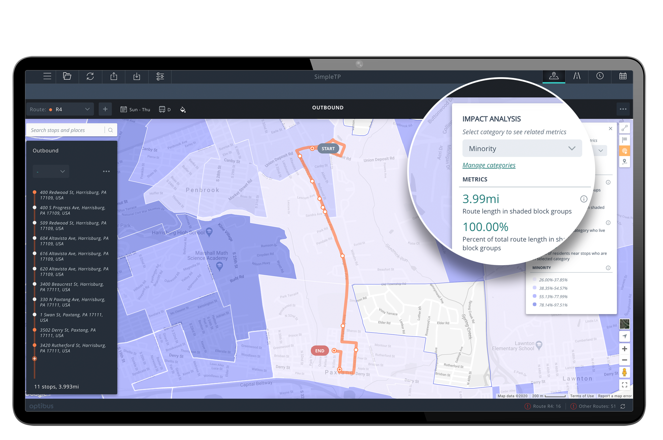
 Optibus' Impact Analysis allows to visualise multiple data layers and evaluate the effects of service changes on your network.
In Optibus it is possible to review network proposals with these policy objectives in mind. By combining a variety of data sources in Optibus, transport planners can gain valuable insights:
- Demographic data: Understanding the population's characteristics (age, income, employment status, car ownership etc.) helps identify areas with specific transport needs.
- GIS layers: Data on land use, infrastructure, and points of interest provide a spatial context for network planning.
- Ridership and demand data: Analysing current and historical passenger flows reveals travel patterns and demand hotspots.
- Existing network data: Evaluating the performance of the current network helps identify areas for improvement.
It’s the role of the planner to weigh these variables and to be able to present options that strike different balances. Decision makers need to be able to make decisions with knowledge of the trade-offs. Inevitably these will be related to:
- Network coverage: The geographic reach of the network.
- Service frequency: Providing adequate service levels to meet current and future demand.
- Connectivity: Facilitating seamless transfers between different routes and modes of transport.
In Optibus, we can test these trade-offs and generate baseline delivery costs at every step of the process. This really enables planners to present data that enables informed decision making.
Furthermore, designing a bus network should not be seen as a one-time event but an ongoing process of iterative refinement. As communities grow and evolve, so too must their transport provision. By continuously monitoring performance, gathering feedback from riders, and adapting to changing circumstances, transport authorities can ensure that their bus network remains effective and responsive to the needs of the community it serves.
If you’d like to learn more about how Optibus can help you to answer the question of who your bus network should serve, get in touch with us for a demonstration of our strategic planning tools today!


.png)